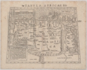
Tabula Africae III

Collection Data

Names
Ptolemy, active 2nd century (Author)
Münster, Sebastian, 1489-1552 (Author)
Dates / Origin
Date Issued: 1545 - 1555 (Inferred)
Place: Basle
Library locations
Schomburg Center for Research in Black Culture, Jean Blackwell Hutson Research and Reference Division
Shelf locator: Sc Map N-192
Genres
Maps
Notes
Content: Text within border on verso: Aegyptum Marmaricam Cyrenaicam.
Content: "Sebastian Munster's version of the ancient depiction of northern Africa, including Egypt, based on Claudius Ptolemy's Geographia from the 2nd century."
Content: The map stretches from Libya to the borders of Egypt. It shows the Nile flowing into "Aethiopia sub Aegypto."
Content: There is a woodcut illustrating Jonah being swallowed by a whale.
Content: Relief is shown by hachures. Mountains are shown by overlapping cones.
Physical Description
Extent: 1 map, 36 x 24 cm.
Type of Resource
Cartographic
Identifiers
NYPL catalog ID (B-number): b16098453
Universal Unique Identifier (UUID): 622c6d00-f015-0131-d656-58d385a7b928
Show filters Hide filters
1 result found